


Informations techniques
-
Distance 6.3km
-
Type d'itinéraire BOUCLE
-
Dénivelé positif 560m
-
Dénivelé négatif 560m
-
Durée journalière 03h30
- Itinéraire balisé : BALISE
- Nature du terrain : Stone
- Nature du terrain : Ground
- Nature du terrain : Not suitable for strollers
- Altitude max. : 1999 m
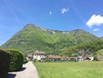
Mid-mountain trail with some remarkable views overlooking the surrounding valleys and mountains, Mont-Blanc, Jura, Bornes-Aravis...
Description
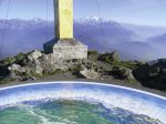
Along this loop, there are numerous viewpoints over the Chablais mountains, Mont-Blanc, the peaks of the Haut-Giffre and the Aravis mountains. As soon as you begin this trail, there’s a breath-taking view over the peaks of the Haut Giffre from a small bench in Le Planey. At the summit of the Pic de Marcelly, there’s a panoramic map on an orientation table!
Animaux
Animaux acceptés : Oui
Animaux acceptés avec supplément : Non
Équipements
- Car park
Services
- Pets welcome
Environnements
- Mountain location
Tarifs
Free access.
Période d'ouverture
From 15/06 to 15/11.
Subject to favorable snow and weather conditions.
Ouverture complémentaire
- Subject to favorable weather
- Subject to snow conditions
Type de clientèle
- Walkers/hikers
- Level red – hard
Thèmes
- Tips : Possibility to do the loop of Lake of Roy when you return back.
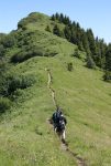
- Guidebook with maps/step-by-step : From the car park, follow a path that departs from the upstream side of the road, and leads to the Pic de Marcelly. Quick uphill walk into the pastures, to the bend where you’ll find Planey ski lift. Here, there is a track to the left for a detour via Le Planey (viewpoint). Then carry on to the ski lift arrival station, and go along the rocky path into the forest. This is an uphill section but it not particularly difficult. When you leave the forest, the narrow footpath quickly leads to the northern side of the Pic de Marcelly summit. Come back via Gron pastures.
Vous aimerez aussi

Pour plus d'informations sur le traitement des données personnelles, cliquez ici.
- This field is for validation purposes and should be left unchanged.