


Informations techniques
-
Distance 8.4km
-
Type d'itinéraire BOUCLE
-
Dénivelé positif 510m
-
Dénivelé négatif 510m
-
Durée journalière 03h30
- Itinéraire balisé : BALISE
- Nature du terrain : Rock
- Nature du terrain : Ground
- Nature du terrain : Not suitable for strollers
- Altitude max. : 1815 m
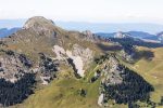
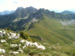
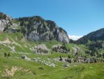
On this pleasant walk, you will be exploring the lush-green mountainside pastures around this fantastic staggering peak.
Description
Besides the green pastures of Chablais, this trail also offers a magnificent viewpoint over the Sommand Plateau, Mont-Blanc mountains and the other surrounding peaks.
Animaux
Animaux acceptés : Non
Animaux acceptés avec supplément : Non
Équipements
- Car park
Services
- Unguided group tours
- Motorhomes allowed
- Accommodation
- Restaurant
- Unguided individual tours
Environnements
- Mountain location
- Presence of livestock and guard dogs
Tarifs
Free access.
Période d'ouverture
From 15/05 to 15/11.
Subject to favorable snow and weather conditions.
Ouverture complémentaire
- Subject to favorable weather
- Subject to snow conditions
Type de clientèle
- Walkers/hikers
- Level red – hard
Thèmes
- Guidebook with maps/step-by-step : From the lake, follow signs for the Col de Cordon. From the mountain pass, go down towards Les Charmettes and then up to Les Charmettes d’en Haut. Follow the path to the Col de Chavannais. Below Haute Pointe, this itinerary crosses over some steep slopes (rocky passage with cables to hold onto), to reach the Col de Chavan. From the mountain pass, it is possible to climb up to the peak of Haute Pointe (1,958m) in around twenty minutes. Carry on to the Chalets du Coin and then follow the farming track to the road, cross the road and then go along the road that leads to the Chalets de la Ramaz, and then the Lac de Sommand.
Pour plus d'informations sur le traitement des données personnelles, cliquez ici.
- This field is for validation purposes and should be left unchanged.