


Informations techniques
-
Distance 19.6km
-
Type d'itinéraire BOUCLE
-
Dénivelé positif 510m
-
Dénivelé négatif 510m
-
Durée journalière 05h35
- Itinéraire balisé : BALISE
- Nature du terrain : Ground
- Altitude max. : 858 m
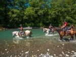
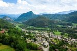
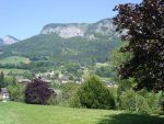
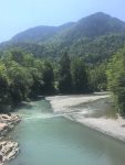
A circular trail between the villages of Taninges and Mieussy, along both banks of the Giffre. A long and varied route, through forests, villages and rivers!
Animaux
Animaux acceptés : Oui
Animaux acceptés avec supplément : Non
Équipements
- Picnic area
- Public WC
- Car park
Services
- Pets welcome
Environnements
- Mountain location
Tarifs
Free access.
Période d'ouverture
All year round.
Subject to favorable snow and weather conditions.
Ouverture complémentaire
- Subject to favorable weather
- Subject to snow conditions
Language spoken
-
 French
Type de clientèle
- Level red – hard
Vous aimerez aussi
Pour plus d'informations sur le traitement des données personnelles, cliquez ici.
- This field is for validation purposes and should be left unchanged.